|
Shirokova Y.I
Morozov A.N.
Salinity of irrigated lands of Uzbekistan: causes
and present state
Ajmal Khan et al (etc.) Sabkha ecosystems. Volume II:
West and Central Asia. 249 -259. 2006. Springer series of book - Tasks
for vegetation science - 42. ISBN: 1-4020-5071-2 â)
Abstract
In article is described existing situation with salinization of irrigated
lands in Uzbekistan. The causes of this phenomenon from natural-climatic
and anthropogenic factors are briefly explained. The role is showed
of ground water in these processes.
Introduction
Most irrigated lands of the Republic of Uzbekistan are subjected to
salinity. This is owing to arid climate, geological and hydrogeological
conditions of irrigated areas.
Primary climate features, which form rate and tendency of salt accumulation
in soils and underlying depositions, are abundance of warmth, moisture
deficit, long hot and dry summer, and short and relatively warm winter.
Radiation aridity index R [1] characterizing connection of between energetic,
water and salt regimes, and also displaying set of environment-forming
factors, varies within 2.5 to 12. Aridity coefficient [2] - Ka <
0.12 - 0.3, continentality coefficient [3] - Kk = 220-290. These indices
are a cause of soil salinity under conditions hydromorphous regime [4].
Irrigated agriculture here till beginning of mass land-reclamation dating
from the middle of the last century was developed at river valley, their
first and second terraces and deltas. Technical capacity of off-taking
water and hydro-geological peculiar properties of the area explained
this. To surface salting only the outlying districts of so-called rivers
debris cone and delta sites of ancient irrigation were undergone.
Plain Central Asia territory has, in a majority, soils naturally salted
and potentially dangerous of secondary salinity development. The Aral
Sea area's lowland is a region of ancient and contemporary salt-accumulation.
Active mountain-forming processes on an area contiguous with the one
are accompanied with continual carrying-out of soil-forming material
inclusive salts and accumulation of that on the plains. Surface and
underground flows have been formed at the Central Asia territory in
the Cretaceous and tertiary periods still continue to act now. On their
motion ways the flows carry salts out of strata being eroded and in
course of their movement they are being enriched with salts of ancient
deposits containing salts. On water motion way they change their chemical
contents and mineralization. Streams running from mountains are partly
discharged into rivers and dips and carry their water as far as zones
of finite accumulation. As a result, thick layers of depositions composing
lowlands during geological epochs were undergone to salt accumulation
dependent on eluvial, transit and accumulative processes [4-8].
As the second source of salts in the region are deep-laid ascending
brines. Though they have a rather local development at a number of deep
dips, nevertheless, they play a great part in forming adverse alkali
soils out off the surface of those salts are carried away to long distance
through aeolian transfer.
At littoral zones of the Aral Sea the third source of salinization is
seawater. Under drying coasts out alkali soils form along the seaboard,
mainly chloride ones, but including sulphate-magnesium and natrium salts.
Soils forming at sea depositions are originally salted. Ancient sea
depositions are "suppliers" of salts, which are carried away
by wind to surrounding plains.
Under the conditions of arid climate, the fourth source of soil salinization,
particularly irrigated ones, are quick soluble salts in the Central
Asia river water. As use of surface flow of the rivers to irrigation
increases their accumulation part in soils and underlying depositions
increases. Since expansion of irrigation to sub-mountain plains and
steppes, area of lands (non-salted at upper, but having considerable
relict salt reserve) potentially subjected to salting have abruptly
increased [5].
Analysis of theoretical and monitoring materials connected by modern
picture of salinity of irrigation soils.
As irrigated agriculture developed, conceptions of forming groundwater
flows and transporting salts by them became deeper, for on those to
a great extent depend success of reclamation on newly reclaimed lands.
Depending on hydrogeological features of a territory, hydrogeologists
and specialists in land-reclamation marked out [6-10]:
- zones of submersion and transit of groundwater flow, generally, fresh
one, hydrocarbonate chemism passing through well permeable depositions;
- zones of pinching out of fresh and slightly salted waters serving
as a source of forming lime and gypseous layers, as well as alkali soils
arising where permeability of strata transporting underground water
slumps;
- zones of secondary submersion (or rather dispersion) generally high-minerailized
groundwater having more prevalence of chlorides where their external
inflow becomes negligibly small, and their level is determined only
precipitation and evapotranspiration (fig.1).
As moving away from mountains natural and artificially formed when irrigating
groundwater flows naturally change their chemism from hydrocarbonate
through sulphate to chloride-sulphate and chloride those [5, 11, 12].
It is noted [5] a significant fact that in the region two kind of landscape
are distinguished highly differing with soil salting processes:
- having relict salinity predominating on the territory with automorphic
soils
- having contemporary salinization occupying without irrigated soils
less than 10 % of the territory, along with hydromorphic soils.
Soils of river valleys within a mountain territory are generally not
salted on the surface, for here falls precipitation amount sufficient
to leaching regime, and groundwater have very low mineralization. However,
even within mountain area valleys zones of forming thick gypsum and
lime horizons in the subsoil layer occur, so called "shokh"
and "arzyk" ridden on falling gypsum and lime out of relatively
cold groundwater, getting into warm horizons thanks to reduction of
these salts solubility as the temperature rises. Besides, here, though
too seldom, zones of high-mineralized groundwater discharge are met
with, salt source of those are relict fields.
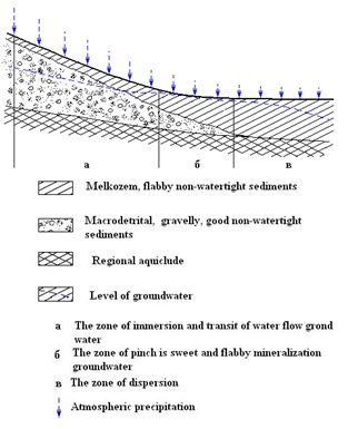
Figure 1. Motion of groundwater under natural conditions and under
irrigation
Main massifs of salted soils in Uzbekistan's natural conditions were
situated just in regional zones of pinching groundwater, even having
comparatively little mineralization of 2-5 g/l, as well at river delta
sites and local lowlands as well. Just there forming alkali soils -
"shory" or "sory" in local dialect, happened, having
also a name as "sebkhy" in literature on salted soils.
As a typical example of zones of forming alkali soils in Uzbekistan
at outskirts of submountain plains serve a sufficiently extensive area
on intersection of the Djizak region and the Golodnaya Steppe.
Zones of spread of alkali soils at big and small rivers' delta sites
exemplified by the delta part (the Karakul oasis) of the Zarafshan river
and Amudarya river (the Khorezm oasis and Karakalpakstan).
Among the most typical lowlands on steppe and desert zones having big
areas of alkali soils can be Shuruzyakskoe and Arnasayskoe lowlands
at the Golodnaya Steppe, Charagylzsloe and Denghizkulskoe at the Karshy
steppe, as well as Tudakulskoe, Shorsayskoe and Shorkulskoe at the Bukhara
oasis.
On regularly irrigated lands as a place for salts accumulation can serve
micro-highlands, which are consequence of bad leveling fields, and,
also, adjacent non-irrigated areas and lowlands to those there is permanent
inflow of groundwater from neighboring irrigated areas (fig.3). In literature
this phenomenon is often referred as "dry drainage". "Dry
drainage" on compactly irrigated lands ensures outflow of salts
from the irrigated fields, if out of them 20 - 40 % and more areas are
not irrigated. Most clearly this phenomenon became apparent at the Khorezm
oasis and no the Karakalpakstan territory.
According to estimate good for irrigation and irrigated soils in Uzbekistan,
more than half is salted to quite high extent.
Classical description of salt transportation in natural conditions under
intensive influence of irrigation and drainage is harshly change both
on local and regional level [4]. Irrigation essentially intensifies
course of natural processes in soils. On fig.2 charts of groundwater
motion under natural conditions and irrigation on various local relieves
are shown.
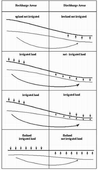
Figure 2. Scheme of groundwater flows and salt transfer under irrigation
conditions.
Under conditions of artificial irrigation soils salinity and trend
of processes depends in the main upon economical activity, since irrigated
agriculture radically changes hydrological regime of soils and hydrogeological
processes on the irrigated areas.
Irrigation canals of reclamation systems form sources of concentrated
supply to groundwater [13, 14].
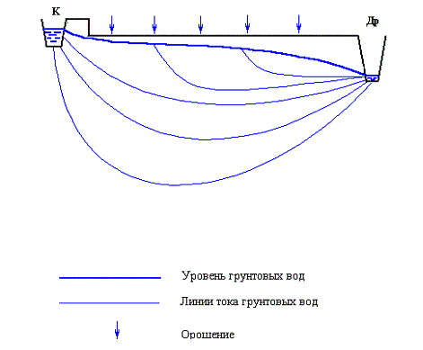
Fig. 3
On fig.3 it is shown how under these conditions prevailing flows of
groundwater form, and a character of forming their local pressure.
This all leads to localisation of sufficiently global (have been existing
before irrigation) hydrogeological and hydrochemical processes, intensifies
many times salt transfer processes and carrying them out to the sources,
because pressure gradients between inflow and outflow elements on irrigated
areas increase several times in comparison with pre-existing under natural
conditions.
Irrespective of climate aridity, salt accumulation process in a soil
is defined by the direction of net moisture flow in the soil layer for
long period of time [15]. In an arid zone, where relatively big water
amount is evaporated and transpired, these processes strongly accelerate,
and to form water-salt regime of a soil it becomes very important by
what means and how the one get there.
It is quite obvious that on the fact how far evenly over the field area
agrotechnical requirements of a certain crop are kept depends its yield.
In accordance with numerous data, a root-existing layer determining
vital functions of plants of any sort (from herbs to wood growth) doesn't
extend than 1 metre [16].
Field irrigation influences upon salt transfer in soils. Irrigation
water in the Central Asia rivers having mineralization at mountains
exits 0.2 to 0.3 g/l, and at lower situated areas - 0.1 g/l and higher
is a strong source of salts to soils, since about 80 % of it is spent
to evapotranspiration, and, on that how the irrigation is being carried
out, how much it fills natural moisture deficiency in the arid zone,
and not useless, by-passing the field surface, feeds groundwater, depends
economical well-being of the irrigated lands and ecological state of
the irrigated territories [4, 17].
On fig. 4 a scheme of forming soil water-salt regime of a field in identical
vertical and horizontal scales is shown.
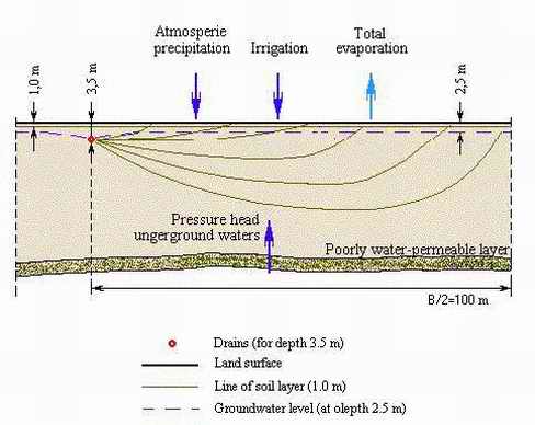
Figure 4. Scheme of movement of water flows and salts at subsoil horizons
on irrigated lands.
On the figure one can see how thin the soil layer is and how accurate
and evenly over the field area irrigation water should be allocated
in order to make the required water regime and, especially, salt regime
in the root existing layer. Poor consideration of this circumstance
results, to a considerable extent, in the problems are being observed
on irrigated lands subjected to salinity in the Aral Sea basin.
It historically has been developed that here only one link on the way
of moisture towards plants in the soil layer has been missed by engineers
and reclamation specialists, namely water distribution technique on
fields which allows, according to reclamation experts, to transfer the
water from free flow state into one of soil moisture.
Perfect irrigation technique is able to solve a set of problems. It
can save up to 40 % of irrigation water on field, it forms water-salt
regime increasing crop capacity as much as twice, enables to meet required
agrotechnical demands when growing crops, prevents deep and surface
water discharge, provides high evenness of water distribution over the
field area, at the same time, thus, settling problems of lands reclamation
state as well.
Current state of irrigated lands relating to salinity, according to
data of the Reclamation Service of the Ministry of agriculture and water
resources, is displayed on fig. 5.
The figure shows general comprehension of salted irrigated lands available
in Uzbekistan.
Fig. 5.
On the fig. 6 allocation of irrigated lands in Uzbekistan's regions
in comparison of 1991 and 2000 years is shown. On it one can see within
that period areas of irrigated lands have considerably risen, especially
in the regions where large land tracts potentially subjected to salinization
were relatively recently reclaimed.
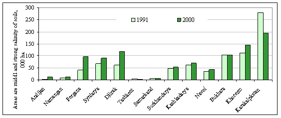
Fig. 6. Extension of salted lands on irrigated areas (according to autumn
soil observations by the Monitoring Service of the Ministry of agriculture
and water resources of the republic).
Even more clearly one can visualize the extent of anthropogenic impact
by analyzing cosmic pictures. On the fig. 7 it has been shown a fragment
of a cosmic picture of irrigated lands on the Golodnaya Steppe. On that
one can see that area salinity depends on economic activity.
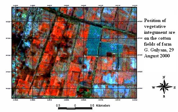
Fig. 7. Fragment of an irrigated area of the Golodnaya Steppe.
Materials of regime observations, brought below as examples (fig. 8),
are indicative of how far dynamically salinity on individual fields
within sufficiently short periods.
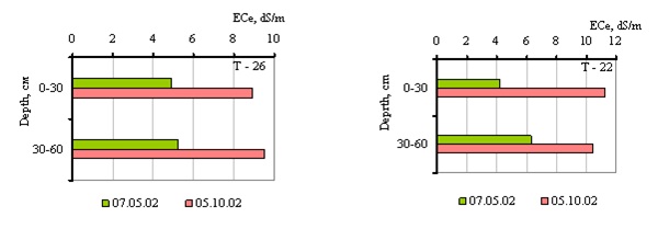
Fig. 8. Seasonal salt accumulation in a soil layer of thickness of
0-60 cm on the test site of the farm after Syddikov in the Syrdarya
region.
Nowadays, under actual existing situation, seasonal salinization of
irrigated lands happens rather owing to tightening of salts dissolved
in groundwater taking place as a result of violation of irrigation regime
than irrigation water quality. At evaporation to root-existing layer,
more often from groundwater salts come in than when irrigating even
with mineralized water.
Approximate balance calculations performed for individual fields (according
to actual observations of the WUFMAS project of 1996-1999) have shown
into the sol layer from the top and the bottom arrives about the same
amount of salts, at irrigation water deliver - 7-8 thousand m3/ha with
mineralization of 1.5 g/l, and depth of groundwater around 2 m with
mineralization of 5-7 g/l. Under insufficient water supply to irrigation
from the surface, even at irrigation with drainage water to 3-4 g/l,
the main part of salts arrives from groundwater because of their high
mineralization (18-20 g/l).
Data of last years' investigations on irrigation water composition and
mineralization of the Aral Sea basin's main rivers testify their increasing
mineralization 21 in comparison with previous years' data 22, 23 . As
it was said above, these waters, playing an important part in salinization
processes of irrigated lands, thus become more and more dangerous in
salt accumulation processes.
CONCLUSION
In this article we have just touched upon principal issues of irrigated
soils subjected to salinity. These consist in the fact that today, however
strange it is, processes of salt transfer and their control just in
soils have poorly been studied, a regional conception of their reclamation
allowing for all economical and ecological consequences of application
of some technical decisions. Under the conditions of the Aral Sea crisis
connected mostly with exhaustion the basin water resources at the current
technical state of hydro-reclamation systems these problems become essential
to the region. To make day-to-day control it is necessary above all
to strengthen the monitoring service of irrigated areas potentially
dangerous with development of repeated salinization. Improvement of
this service is regarded by application of remote mapping technology
in conjunction with GIS methods. Besides, wide application have to find
those of ground simplified operative monitoring over salinity extent
to control soil salinity on certain fields during vegetation 24 .
REFERENCES:
1. Budiko M.I. Global ecology. Moscow, "Mysl", 1977. 318
pp.
2. Lobova E.V., Ostrovskiy I.M., Khabarov A.V. On determination of dryness
of arid regions of the world. // Deserts development problems. 1977.
#4. pp. 31-40.
3. Ivanov N.N. Landscape-climatic zones of the globe.// Notes of World
Geographical Society, M.-L., the USSR Academy of Science's publishing
house, 1948. 224.
4. Parfenova N.I., Reshetkina N. Ecological principles of hydrogeological
regime regulation of irrigated lands. Saint-Petersburg, "Hydrometeoizdat".
1995, 360 pp.
5. Pankova E.I., Aydarov I.P., Yamnova A.M., Novikova A.F., Blagovolin
N.S. Natural zoning of salted soils of the Aral Sea basin (geography,
genesis, evolution). M., 1996. 180 pp.
6. Fedorov B.V. Agro-reclamation zoning of Central Asia irrigation area.
Tashkent, the UzSSR Academy of Science's publishing house. 1953. 150
pp.
7. Krilov M.M. Basics of reclamation hydro-geology of Uzbekistan. Tashkent,
"Fan" publishing house, 1977. 248 pp.
8. Vladimorov A.G. Reclamation hydro-geology. M., "Gosgeoltechizdat",
1961.
9. Kats D.M. Influence of irrigation upon groundwater. M., "Kolos",
1976.
10. Shreder V.R. Soil-reclamation zoning and calculation regimes of
irrigation. Report on totality of works had been performed, represented
to competition of academic degree of PhD on agriculture. Tashkent, 1973,
29 p.p.
11. Panin P.S. Salt delivery processes in soil strata being leached.
Novosibirsk, "Nauka", 1968. 303 pp.
12. Khasanov A.S. Features of forming subsurfacewater chemical contents
and groundwater regime. M., "Nauka", 1964, pp. 106-110.
13. Fedorov B.V. Principles of building reclamation system to prevent
and liquidation of irrigated lands salinity. Influence of irrigation
upon repeated salinization, chemical structure and regime of underground
water. M., "Nauka", 1964, pp. 49-53.
14. Khodjibaev N.N. Big irrigation canals as pressure-water systems,
and their influence on reclamation state of lands. Influence of irrigation
upon repeated salinization, chemical structure and regime of underground
water. M., "Nauka", 1964, pp. 162-166.
15. Averjanov S.F. Control of irrigated lands salinization. M., "Kolos",
1964, 288 pp.
16. Stankov N.Z. Root system of field crops. "Kolos", 1964,
280 pp.
17. Morozov A.N. Systems approach to determination of development strategy
of hydro-reclamations. Report at the research conference "Present-day
problems of reclamation and water economy, and ways of their settlement"
dedicated to SANIIRI 75th anniversary. Jubilee research articles of
SANIIRI, Tashkent, 2000. p.6.
18. Shirokova Y.I.
19. Chembarisov E.I., Bakhritdinov B.A. Hydro-chemistry of river and
drainage waters of Central Asia. Tashkent, "Ukituvci", 1989.
132 pp.
20. Rubinova F.E., Ghetkher M.I., Kuropatka L.M. About change of general
water mineralization in the Syrdarya r. due to conducting irrigation
in its basin. // SANIGMI transactions, 1975, issue 23 (104). pp. 43-58.
Shirokova Y.I., Chernyshov A.K.
How
to get in touch with us?
Return
to the main page
|