A.N.Morozov
(GIP)
L.I.Chistyakova (Engineer)
"Vodproject" Association
S.S.Khamzin
(Chief Soil Scientist)
T.I.Khamzina (Chief Specialist)
"Uzmeliovodkhoz" Institute
INVESTIGATION OF PREDOMINANT WATER FLOW FORMING IN THE SOILS OF
THE DJIZZAK STEPPE
Conception of moisture predominant flows in soils through non-capillary
pores was formed long ago [1]. Direct visual [2] and instrumental
observations [3,4] testify that moisture, at irrigation or precipitation,
rate of which exceed soil's absorbing capacity, moves by two main
ways: via non-capillary pores and fissures (predominant flows, not
connected with the soil) and by capillary pores in the form of flows
connected by sorption-capillary forces.
In this relation, Uzbekistan soils are studied not enough. Beside
of sand and light loamy soils, other soil types contract and highly
fissure under dehydration after irrigation or raining. Moreover, natural
capillary porosity is typical of them, which is formed by plants'
roots and living organisms available in the soil. These properties
determine significant moisture and salt transfer features in an aeration
zone, particularly in a root-inhabited layer of the soil. At irrigation
of salted soils, this brings to reduction of their desalination efficiency,
and after introduction of freely soluble fertilizers and following
irrigation - to fast carry-over of the fertilizers out of a biologically
active soil layer and to groundwater pollution.
In Uzbekistan,
study of this phenomenon in salted and salt-subjected soils is of
particular interest. To forecast such in soils moisture-salt transfer
processes, it is necessary to know a aeries of parameters those allow
exact calibrating imitation models, adequately reflecting natural
processes. Modeling is needed to comprehend water movement nature
in a soil unsaturated zone and their lower strata for solving a series
of problems related to general control and estimation of predominant
flows' influence on the environment. In addition, modeling enables
to forecast these processes and efficiently estimate alternative technologies
of irrigation and leaching. To assess properly a risk of soil and
groundwater pollution, reduce or prevent it, it is essential to model
processes of water movement through the soil with sufficient accurateness.
For in-depth study of moisture and salts movement process in soils,
within of the first investigation year of project # 436 of INTAS Food-2000
Program, we selected mean loamy soil on loess-like loams as a typical
of Uzbekistan soils; since soils of such or close properties occupy
about a half the area of all irrigated lands in the republic [5, 6].
The investigation
objective is determining a characteristic of Uzbekistan typical soil
by variability of moisture absorption from surface and its movement
in the soil in the form of predominant flows.
Purpose of the experiment described in the article was study of moisture
flow and salts forming and their distribution over the area at diverse
depths, by means of micro-lysimeters.
Moisture
flows predominant in a soil were studied using micro-lysimeters installed
at the sub- plough-layer depth (35 cm) and at the horizon (70 cm)
in order to detect flow irregularity because of fissures, large pores,
and shrew's motion holes available therein.
Experiments' principles are simple enough: in the sidewall of a soil
monolith, two recesses were made (the upper and ceiling walls of the
recesses at depth of 35 and 70 cm, respectively), where the micro-lysimeters
were set. Recesses laying depths were selected based on the ideas
as follows: the micro-lysimeters at 35 cm depth were supposed to characterize
moisture flows formed in a soil layer of destroyed structure; and
the micro-lysimeters at 70 cm depth were to characterize moisture
flows lower of the root-inhabited layer. Micro-lysimeter is a set
of glasses of 5 cm in diameter placed in special pans and covered
on the top with a polyethylene gauze to prevent soil mud-streaming
under soaking. After installation of the micro-lysimeters into the
recesses, the glasses were strongly pressed to the soil's upper surface.
Installation scheme is shown on figure 1; arrangement of the glasses
on figure 2.
Soil surface
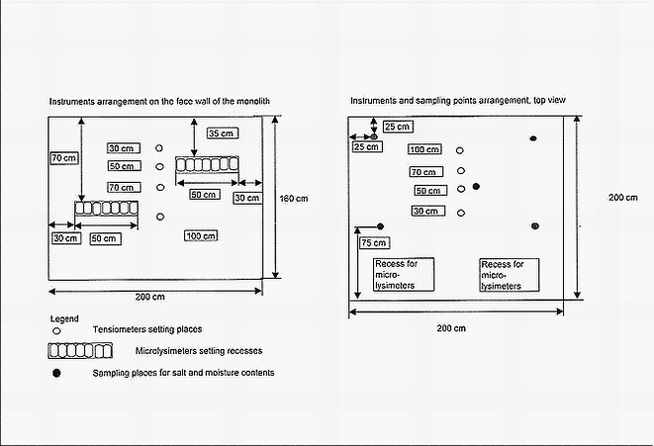
Figure 1. Installation scheme of micro-lysimeters (view from the sidewall's
side of the soil monolith).
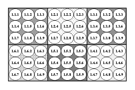
Figure
2. Scheme of the glasses arrangement in the micro-lysimeter's pan.
The first figure in the circle is glass' number; the second ' number
of a combined sample out of 9 glasses; the third - glass - order number
in the combined sample. By the same hatching are circled the glasses,
out of which a filtrate was combined for analyses.
The investigations
were conducted in the Djizzak Steppe on a rolling prolluvial plain
with easy wavy relief ("Bakhrom" farm). Soils investigated
- "light sierozem", irrigated more than 10 years, low-humus
(humus concentration is 1.0-1.5 % in the horizon), relatively non-salted
in the upper one-meter layer. To characterize their water-physical
properties, the soils were preliminarily determined layer-by-layer:
soil volume weight; granulometric and micro-aggregate structures;
characteristics of the capillary-sorption potential, water absorption
from soil surface and from lower level of the plough-layer.
On figure
3, analysis results of the soil granulometric and micro-aggregate
structures by horizons are shown.
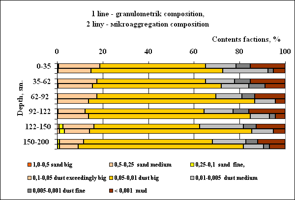
Figure
3. Granulometric and micro-aggregate structures of the soil
Character of a granulometric structure of this soil sort is prevalence
of rather dust fractions (0.01 - 0.05 mm) in all the horizons studied.
Simultaneous comparison of the granulometric and micro-aggregate analyses'
results is evidence of availability of coarse-dust-size micro-aggregates
in the fraction, which were formed from smaller fractions.
On figure
4, it is presented a curve of volume weight values of the studied
soil in its depth; that clearly shows characteristic increase of this
weight in depth and availability of so called "sole shoe",
that is a compacted layer, at the border of the plough-layer and sub-
plough-layer.
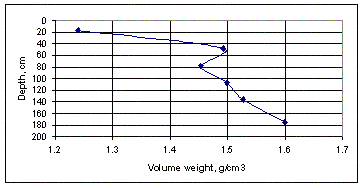
Figure
4. Soil density by horizons, g/cm3.
On figure
5, it is shown curves of capillary-sorption potential dependence on
moisture (pF curves) for horizons B (35-62 cm), C (62-135 cm), and
D (135-180 cm). These data characterize the soil and its substrata
as sufficiently homogenous and similar by sorption properties, typical
of rather dust loess-like loams.
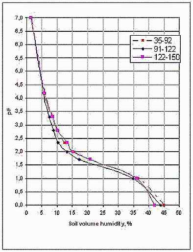
Figure
5. Capillary-sorption potential dependence on moisture (pF = f(W))
of B, C, and D horizons of the studied soil.
Water permeability of the studied soil is characterized by the absorption
curves at water head of 2 cm over the soil surface, in a monolith
of 200x200 cm, isolated with polyethylene film from spreading towards
sides down to depth of 160 cm.
On figure
6, various water absorption characters are seen during the I and II
irrigation, explained by occurrence of contraction cracks in the soil.
To define absorption heterogeneousness, spot measurements of the absorption
speed were carried out over the area by means of tubes of 9 cm in
diameter, buried into the plough-layer' surface at 10 cm length between
each other in three tubes in abreast.
On figure
7, it is seen how far the absorption speed of some tubes varies, located
on relatively small area of an undisturbed ground, obviously not having
large fissures and shrew's motion holes. To the end of the experiment,
minimum speed's deviation from the maximum one came to 280 %, and
from the average one - to 140%.
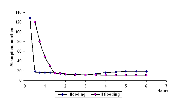
Figure
6. Absorption curve on an area of 200x200 cm, isolated from spreading.
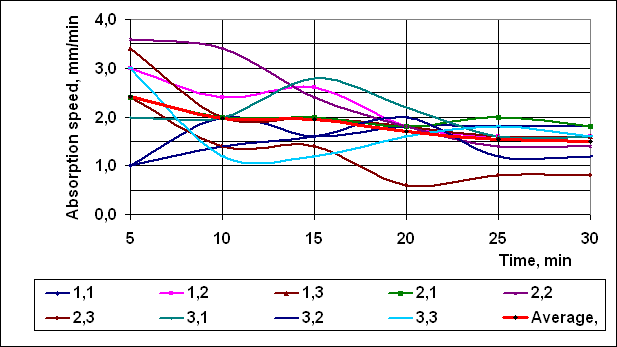
Figure
7. Absorption speed curves over the undisturbed sub-plough-layer (it
is numerated: the first figure - row's number; the second - filtration
tube's number).
The results stated above characterize properties of the studied soil
as sufficiently typical of mean loamy light sierozems on loess-like
loams.
Experiment's operational hypothesis consists in that at saturation
from soil surface, moisture moves by two ways: through pores (main
movement) and vie soil blocks separated by fissures and pores. Until
full saturation of the soil layer over the micro-lysimeters, soil
moisture can get their glasses only via large pores, for in the small
pores, it is kept by capillary-sorption forces.
The experiment itself consisted in supplying uniform salts solution
layer to the soil surface and differentiated measurement of the filtrate
flow using the micro-lysimeters.
Two irrigation actions on the test site were carried out; the first
- of 125-mm rate with CaCl2 solution of 0,002М concentration; the
second - of 50-mm rate with MgCl2 solution of the same concentration.
The filtrate was gathered in the micro-lysimeters' glasses.
After conducting irrigation, the micro-lysimeters were drawn out of
the recesses, filtrate volume and specific electric conductivity in
the each glass were measured.
Filtrate volume probability (%) in 48 glasses set at depth of 35 cm
is shown in picture 8; in figure 9, specific electric conductivity
dependence on the filtrate volume is presented.
Experiments' results are evidence of very uneven water filtration
via the plough-layer (fig.7) and of pronounced trend of salts solutions'
getting through along with predominant flows (fig.8).
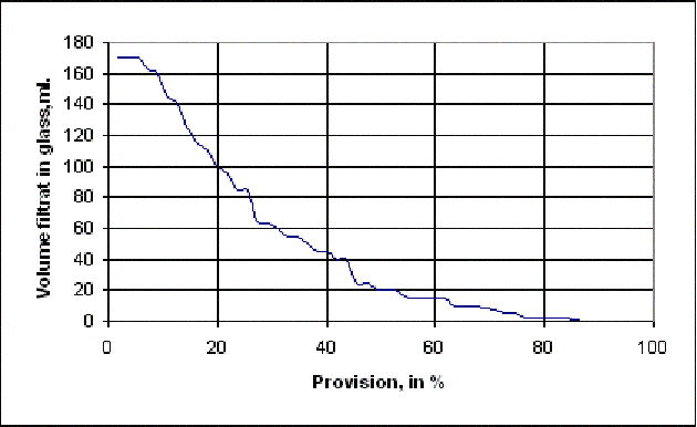
Figure
8. Filtrate volume probability curve in the micro-lysimeters' glasses
(%)
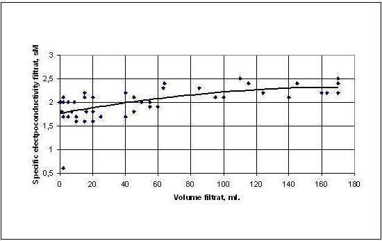
Figure
9. Curve of filtrate's specific electric conductivity dependence on
its volume in the micro-lysimeters' glasses
Since in some glasses the filtrate was absolutely absent, and in others
that was not enough for making chemical analysis, we made 6 samples
those combined a filtrate out of 9 glasses (from 1.1.1 to 1.1.9 and
so on, see fig.2). In the figure 10, curves of dependence of the specific
electric conductivity, dense residue composition, and Na and Cl ions
on the filtrate volume in each sample combined out of the 9 glasses.

Figure
10. Curves of the specific electric conductivity, dense residue composition,
and Na and Cl ions dependence on the filtrate volume.
In the picture of the soil surface between I and II irrigations (fig.11),
you can clearly see sufficiently large contraction cracks (1-7 mm
wide).
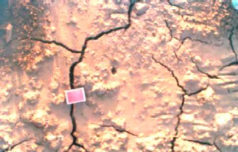
Figure
11. Contraction cracks on the soil surface after the first irrigation.
Into the micro-lysimeters' glasses installed at depth of 70 cm, as
it was expected, got moisture substantially less than in those installed
at 35 cm depth, and, therefore, even the specific electric conductivity
was a success to be measured only in the combined samples out of the
9 glasses. The results achieved (fig.11) are evidence of a strongly
pronounced trend towards salts concentration rise in the filtrate
depending on its volume in the glasses.
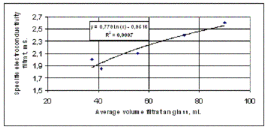
Figure
11. Curves of the specific electric conductivity dependence on the
filtrate volume in the combined samples of the micro-lysimeter set
at 70 cm depth.
The results gained allow drawing a few conclusions of scientific and
methodical character:
1. Despite seeming soil uniformity, formed of loess-like mean loams
highly homogenous by the granulometric structure, and the soil's plough-layer
destroyed because of long-term tillage, uneven filtration is observed
in the sub-plough-layer.
2. Water absorption character under repeated flooding the area testifies
to forming of new contraction cracks in the plough-layer, which is
confirmed by apparent soil surface breach.
3. In the monolith volume, great unevenness and heterogeneity of the
water flow are observed, and salts with water are transferred by predominant
flows via larger through pores.
4. In further investigations, one should extend an irrigation time,
increase a salts solution concentration, and select samples out of
a micro-lysimeter by portions in certain time intervals for exacter
fixation of water predominant flows to sub-soil horizons.
References
1. D.G.Vilenskiy.
Soil aggregation: theory and its practical application. Moscow-Leningrad:
1945, 111 p.
2. P.S.Panin. Salt return processes in leached soil strata. Novosibirsk:
Nauka, 1968, 303 p.
3. A.D.Voronin. Structure-functional hydrophysics of soil. M.: Moscow
State University, 1984, 204 p.
4. Van Dam J.C., Huygen J., Wesseling J.G., at al. Theory of SWAP
version 2.0. DLO Winand Staring Centre, Wageningen, 1997, б. 55 -
65.
5. Atlas of Uzbekistan soil maps. Tashkent: Usghiprozem, 2001.
6. Soil-meliorative zoning of Uzbekistan. "General scheme of
irrigated agriculture and water management development in the Republic
of Uzbekistan to year 2015 ". Tashkent: Ministry of Agriculture
and Water Resources, "Vodrpoject " Association, 2002.
How
to get in touch with us?
Return
to the main page