Morozov
A.N.
Lecture 9. How water
is getting into soil?
Considerable amount
of water is requires for life sustaining of plant roots and of main live bodies
(phytogenous and zoogenous) that "live" in the upper layer of soil since
most part of the energy coming from the sun is spent for moisture evaporation
which means for soil aridization.
Stored soil moisture is refilled owing
to rains, snow, dew falling, irrigation and ground waters feeding (either in a
way of moving in liquid state, or by steam transfer). And also, ground water itself
may be refilled owing to onflow from other territories or by means of precipitation
and artificial irrigation.
It was told much
but it is difficult to understand, wasn't it? Now, let us investigate in a way
as our English friends say "step by step" which means little by little
Naturalistic
system is as nipple…
If naturalistic system of "different-calibre"
galleries in the soil is not disturbed artificially with tillage then even rainfalls
do not cause surface run-off, puddles, and the soil fully catches moisture. Water
penetrates rather deep into the soil along major galleries and moistens the soil
like by arteries.
Soil in natural conditions,
usually is covered with porous, high permeable "blanket" - sod layer
- like felted fabric made of plants remains and roots (Picture 9.1). Moisture
is preserved miraculously in liquid state under this "blanket" indrawing
from lower horizons, and noghtly it is condensed from environment air at cooled
particles of soil.
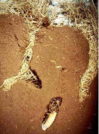
Picture 9.1. Sod layer and earth-boring dung
beetle galleries in undisturbed soil.
It is significant for moisture
regime of soil that sod layer properties of the device known in engineering under
name "nipple" - water flow down easily, but if up - then sorry - economically
very much. The point is that soil and subsurface substance are as a reserve tank
where water surplus flows down fast along large -size pores when precipitation
and irrigations take place, but from there the surpluses are "protruded"
to the upper soil layer economically very much (by other ways indrawing in the
form of film moisture in liquid state, and by another way - in the form of steam
along large-size porous)
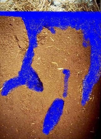
Picture
9.2. Rapid inflow of sod layer and soil pores with water during rainfalls and
irrigations
Owing to high content of organics,
sod layer has a number of high spots:
first of all - it has very low thermal
conductivity and it protects from overheating and subcooling, and it reduces evaporation
and it does not hurt to the soil "living bodies";
secondly - it
is very freely permeable for water and air that are necessary for the soil "living
bodies";
thirdly - it is "eatable" for the soil "living
bodies";
the fourth - the most important thing, sod layer and roots
derived products that are the very things needed for vegetation growth (we shall
tell about that in the corresponded chapter on soil fertility).
It was shown at the next Picture 9.3 how water plumped into large-size cracks
and pores after heavy shower, and immediately simply is absorbed by soil.
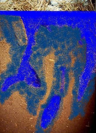
Picture
9.3. Water "absorption" from large-size cracks and pores after heavy
shower or soil surface flowage during irrigation (not only at sprinkling).
All the surplus water "flow down" fast in automorphous conditions with
hanging up at upper horizons that were over-moistened excessively of equilibrium
condition for very short period of time.
But
in hydromorphous conditions soil over-moistening may be more continuous because
here excessive water may drain only by underground way, or may be spent for evaporation.
That is why automorphous soils are warmed-up more rapidly, they can provide earlier
their "living bodies" with warm, but they also are dried up earlier
unlike hydromorphous soils which remain cool and moist for long period of time.
And, what is happening when natural sod layer
has been disturbed with tillage, and "plough pan" has developed in the
subsurface -that is the layer overcompacted by machinery so much that not any
ripper is able to break it?
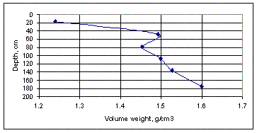
Picture
9.4. Diagramm showing soil density variation (g/cm3) in depth (arable soils).
It is clearly seen that at depth about 35-45 cm soil density increases sharply
at the expense of multiple passes of heavy machinery at tilling and after plough
passes in waterlogged soils.
As a consequence, ultimately, the "nipple"
system stops working, or the "nipple" system is glitching - water penetration
capacity is reducing several times during few years because the pores developed
owing to the soil "live bodies" and including formed by plant roots
were disturbed. That not only deprives of the soil "live bodies" from
food, air and moisture, but also creates conditions for formation of surface run-off
when heavy rains and intensive snow-melting take place.
As
a result - outwash of soil covering, surface water and wind erosion, gullying.
And the plough-pan, having higher density, which is almost equal to rolled asphalt,
blocks moisture exhausting from ground waters to plowing horizon even supposing
they are close to each other, and that is why it deprives plants roots from water.
Now, we shall tell you about how ground waters
are formed and flow (which "gradually turn into" underground waters).
Please, have a look at Picture 9.5 and try find out- which diagram displayed to
the right and to the left at it is most of all reflect the situation at your field?
Take your time! Please, call to mind, which
kind of topography has your field, where is located your field - weald or on lowland,
what kind of fields or agricultural lands are situated close to it, if they are
irrigated, if there are dry hills, wet meadows, swamps or salines. If wells or
bore holes could be found there, at which depth could be found water at them,
quality of it (smooth, hard, brackish or fresh?). Depending on everything you
reminded about your field you may find right answer which is related to the main
question of this chapter.
Do not explain too
much that because of I. Newton was hurt by an apple (:-)), water always flows
from top donward, and owing to B. Pascal (:-)), it flows to depressions as it
is in communicating vessels. And the same - in soils and in underlying grounds
(substrates) it flows downward to depressions or to lands with lower ground waters.
This phenomenon may be called as fundamental law of hydrogeology - science on
underground waters. The area, where underground water flows are formed is accepted
to call as feed zones, the sites where they flow, wedge out in the form of springs
or where it is evaporated - they are called as discharge zones.
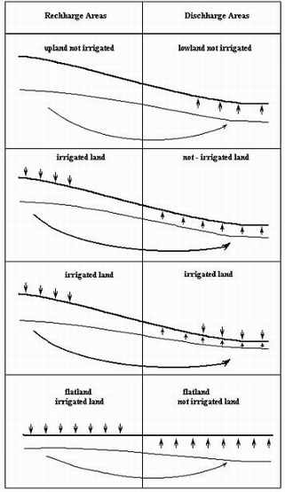
Picture
9.5. Types of ground water feedings of the fields depending on topography and
irrigation of "neighboring" territories. It is associated with communicating
vessels, isn't it?
We shall be back to this
picture later in another lecture on waterlogging and salinzation of irrigated
soils and on drainage necessity. But already now I'd like to tell you about why
feeding of soil with ground waters in most cases brings to hell of a mess.
The
point is that all the natural ground waters have rather high content of dissolved
salts in them. Very seldom salt content in them is no more than 1 gram per liter,
usually salt content from 3 to 5 grams is considered as rather good rate, and
5…10 gram per liter - as quite appropriate. If during summer season 3000…3500
tons of ground water is spent for evaporation at a plot with area 1 ha which is
in discharge zone, then at least from 3,0 up to 3,5 tons of salts is remained
in topsoil of the plot!
You may check the calculation:
1 ton of water is 1000 liters. If 1 liter of water contains 1 gram of salt, then
it will be 1 kg of salt in 1 ton of water. That means after evaporation of 3000
tons of water 3000 tons * 1 kg = 3000 kg, or 3 tons of salt. It is not too much,
but after ten years saline will be guaranteed if no measures are taken. And if
ground water mineralization is 10 g/l, then soil salinization is appeared approximately
10 times faster
However, it is vast subject,
it is better to change to closer of our fields and vegetable gardens practice,
but before that, we take mind off the things a little and describe in brief how
water is delivered to our fields. That may be is not too interesting, but it would
be useful for understanding how harmful water losses from the delivering canals
are for our sites.
Arrangement almost of any irrigation system was shown
at Picture 9.6. Sometimes some parts of the system may be absent because of uselessness,
for example, water reservoir, pump station or main canal, but it does not change
core of the subject. Apart from irrigation network, many systems are also equipped
with drainage and escape network for draining of storm waters and of surplus of
irrigation water, that are formed by water losses from canals and fields.
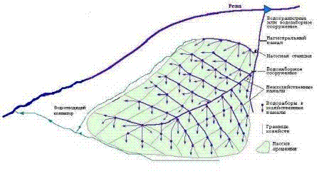
Picture
9.6. Assembly of irrigation system
From 10
up to 40% of abstracted water amount at the head of the system are lost from unlined
canals. Water losses are not more than 5…10 % take place at canals lined
with concrete or at canalettes.
As far as
canal routes are designed along higher surface points with the purpose to "command"
over irrigated fields (i.e. to have gravity irrigation without usage of pumps),
then losses create a sort of ramified system of pressure waters feeding ground
and underground waters
That is feeding not
through soil surface at fields, but from canals directly to ground waters, and
that brings to the fields waterlogging more often than not, and if deep layers
of subsoil contain salts then that also brings to their salinization. Therefore,
almost all irrigation systems are equipped also with drainage and escape network.
Please, look at the Picture 9.6 once more.
It is almost perfect analogy of human organism, is not it? There are arteries
that deliver blood to the organism cells, veins carry off polluted blood with
sorts of waste (slags) for cleaning, but only one misfortune is there - absence
of devices - analogues of liver and kidneys in our irrigation system, where the
waste would be separated, deposited and detoxified.
And further, drainage
and waste waters are directed to whatever depression or spilled back to the river.
Here is something to think hard for ecologist! Of course, if they really worried
with environment state.
If irrational irrigation technique is used for fields
irrigation, then very seldom may be achieved level higher than 40% of efficient
using of water obtained at the head of the system (about of the half of amount
is lost in the canals system, and lost at least 30% of water amount relatively
to delivered up to the fields, and you can calculate - how much of it is used
efficiently, and how much harmfully)
Therefore
in the next chapter we shall try to understand how to maintain required for our
plants moisten regime in soil and do no harm thereat to it.