Morozov
A.N.
Lecture 4. Soil-meliorative zoning, what for
is it and which abilities does it open?
Possibly you know from elhi
textbook that there are climatic zones on Earth: starting from equatorial up to
polar ones. Species composition of flora and fauna change in line with climate.
If we inspect the Nothern hemisphere of Earth then we find following zones are
allocated on maps of vegetations cover in the direction from north to south:
- Cold deserts;
- Needle-leaved forests;
- Mixed forests;
- Leafy
forests;
- Forest steppes;
- Steppes;
- Deserts.
Accuracy of these zones in the latitudinal direction is broken only by different
local conditions - availability of mountains, big water reservoirs or seas. In
actual fact all of these listed zones perhaps except Cold deserts are available
in Uzbekistan, though it is situated in the zone very close to subtropical zone.
Instead of cold deserts there are mountain deserts located upper Alpine meadows.
In mountains, where climatic conditions are changed with increase of elevations
and visually we can follow up vegetation cover change depending on the increase
of elevations. Large water reservoirs impact on climate of adjacent territories,
making it more soft it and increasing its humidity. Separation to zones
in accordance with vegetation cover, elevations or by other characteristics is
named as zoning.
Wildlife plants grow in each climatic zone and altitudinal
belts that adapted in the best way for these conditions. Being aware of that nobody
will not plant palms in the zone of Needle-leaved forests and vice versa! Desert
plants do not grow in mountains and mountain plants - in steppes and deserts,
though these sites can be found very close to each other in the same altitudinal
belt.
Generally, "zoning" term can be used to any map where natural
conditions of the territory was reflected in one or another scale
Maps, where
"zoning" was done relatively to land configuration are called as topographical
maps, and if according to soil covering, then they are named soil maps. When the
map reflects combination of several properties of surface at the same time, then
it is called synthesized (combined) map. Collection of diversified data on maps
was resulted on appearing of very illustrative and convenient form of presentation
of so called soil-meliorative maps. - Following
maps were used as basis for soil-meliorative maps:
- Topographic maps,
- Geobotanical
maps (vegetation maps),
- Soil maps,
- Litho-hydrogeological maps
(maps reflecting structure of the Earth crust and of ground water properties),
- Climatic
zonation maps.
Such combined maps, showing soils forming
conditions and of their genesis and discovering reasons of meliorative problems
were as foundation and constituent part for development of a number of thematic
zoning - technique and methods of irrigation, drainage types and capacity, soils
fertility assessment e.t.c.
Actually, computer software makes it possible
keep various information as it was in different "layers" of information,
and overlay these "layers" one over another if needed. We can see such
overlay example in our Lecture 1 "Natural conditions of Uzbekistan"
at Pictures 1.2 and 1.3. Picture 1.2 contains 2 "layers": satellite
image of the territory and administrative borders of states and oblasts, and Picture
1.3 - contains only satellite image.
Modern Geographical Information Systems
(so called GIS - technologies) make it possible synthesize many different kind
of maps, for example using topographical base reflected landscape combine with
climatic, soil and other maps. It is also easy by using GIS technologies to mark
out territories that are similar by their natural conditions. Determination of
sites on the maps with similar natural properties allows to farmers to identify
crop pattern in advance, and engineer-meliorators may easily to determine where
and which kind of meliorative measures should be taken to develop best conditions
for crop cultivation without carrying on long term preliminary and expensive investigations.
We show climatic conditions zoning of Central Asia territory as an example
at Picture 4.1. This map allows determining climatic conditions typical for any
site with satisfactory accuracy for common use. 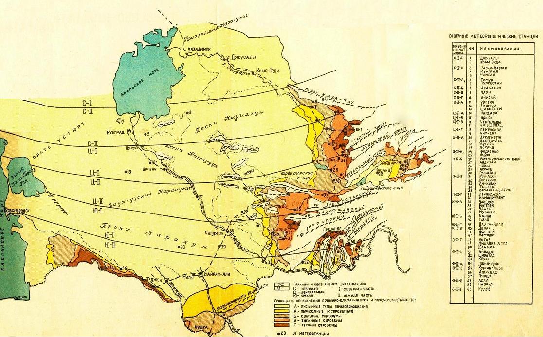
Picture
4.1. Diagram of Soil - Climatic Zoning Inasmuch as climatic conditions differences
depend on latitudinal location and on vertical zoning, then for practical purposes
of water distribution rationing Central Asia territory is divided into three zones:
North (N), Central (C) and South (S), each of them subdivided into north (I),
and south (II) parts. Separation for soil-climatic zones and belts is based on
quantity indexes of precipitation amounts, temperature conditions and air humidity.
Belt and altitudinal zones along vertical zonality are allocated in each climatic
zone, description of that was given in Table 2.1, and quantitative characteristics
in terms of coefficient of natural humidity (CH) were also shown there, which
is roundup index of thermal and water resources of the area, and it is determined
by following formula: CH = (пн + Wо)/еН
where: пн - average
of long term precipitations for period of the year with having air temperature
higher than +5яН, mm; Wо - moisture content in soil layer of 1 m thickness
for the moment of base period beginning, mm; еН - potential evaporation
for accounting period, mm. CH factor meaning is that it shows relationship
between accessible natural moisture reserves for plants (precipitations over warm
period, plus moisture content accumulated in soil over cold period) and potential
evaporation during summer (vegetation) period. The smaller this index, then the
more arid climate is.
Belts of vertical zoning are different by moisture
conditions during winter - spring period. Precipitation amount is increasing from
а belt to ц one and period of natural moistening is also increasing. But summer
period and beginning of autumn are of the same aridity and there is small difference
in temperature conditions between them. You may be assured by that after looking
at information shown at Pictures 1.4 - 1.9 of Lecture #1. Table 4.1. Coefficient
of humidity for belts of vertical zoning.
Zone | Belt |
Type of soil formation (automorphous row) | Coefficient
of humidity | Deserts |
A | Deserts |
0,050 - 0,10 | | A1 |
Transition to serozem belt |
0,10 - 0,15 |
Ephemeral steppes
|
а | Serozemic |
0,10 - 0,20 |
Light serozems | |
б | Serozemic |
0,15 -0,25 |
Typical serozemsDesert (arid) |
Forb steppes |
ц | Serozemic |
0,25 - 0,30 |
Dark serozems | As was said before, when
soil-meliorative zoning is developed then following soil formation factors besides
topography and climate that determine conditions of irrigation and cultivation
of any soils type are taken into account: - Soil conditions;
- Hydrogeologic
conditions;
- Litho-hydrogeological structure.
Most
constant among the factors which determine many soil properties relatively to
water and its moving through soil are properties of pedogenic (soil forming) rock
properties that significantly depend on particles size forming soil (particle
size distribution).
Here are these properties:
- Degree of aeration;
- Water permeability;
- Water holding capacity;
- Wicking
properties;
- Thermal conditions etc.
We shall
discuss on each of these most important properties in following lectures.
For the time being we'll tell you only about number of main soil properties that
determined by particles size forming it: Sandy and sandy loam soils have
advantageous air and thermal regime, (i.e. they are well water- and air - permeable
and have quick warm-up property), but they have poor moisture holding capacity.
Clayed soils have high moisture holding capacity, low water permeability,
poor water return, high bulking and disadvantageous thermal properties. Loamy
soils, having intermediate position according to their properties and composition
are optimal. The soils have advantageous air and thermal condition, have high
permeability, have high moisture holding capacity and soil moisture mobility. For
the purpose of allocation of irrigation schedules (terms and periods of irrigation
rates for any crop) following five main groups of soil forming materials were
identified that differed from each other: 1 - Sandy; 1Ю - Shallow,
rocky; 2 - Sandy loam; 3 - Light- and medium- loam; 4 - Loamy
(firm) and heavy-loam; 5 - Clayed. Evaluation of hydrogeologic conditions
(i.e.location and mineralization of ground waters) is based on hydrogeologic-
and soil-meliorative zoning, and main criteria for which is groundwater equation
determined by conditions of their feeding and discharges (drain, transpiration
and evaporation).
With taking into account these characteristic values following
hydrogeologic-meliorative areas are allocated there a - of secured drain,
groundwater passage in conditions of deep GWL that have no influence to soil development; a1
- of secured local drain of groundwater owing to roughness of the area; А
- of intensive outer feeding, backwater and groundwater discharge with stable
and close groundwater table; Б - of hindered feeding and draining of ground
waters with non-stable depth and regime which depend on local conditions. 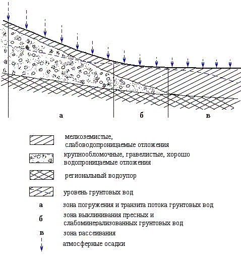
Picture
4.2. Schematic view from mountains to flat area explaining allocation of hydrogeologic
zones. Terrain conditions and lithological composition of soil forming materials
determine soil-meliorative state in "a" and "a1" areas. Their
division is important only from genetic point of view, but in no way that has
influence to water discharge for evaporation and transpiration.
Major
differences in "А" &Б" areas are due to water exchange type
(amount and intensity of feeding and draining) of groundwater and hydro-chemical
zonality connected with it. The areas are divided depending on location (elevation)
of ground water, and also on their mineralization. Areas with fresh water are
labeled by "А" and "Б" indexes; areas with mineralized ground
water (more than 5 g/l) are named by "á1" and "â1"
indexes in accordance with belonging hydrogeologic-meliorative area. About
influence of hydrogeologic conditions to soil formation processes, and especially
to soils salinization, we shall tell you more detailed in one of final articles,
in as much as to understand rightly the very core of processes that take place
in soils you should have sufficient knowledge for that. So, we described
you about where which climate is; amount of precipitations in mountains and at
flat area; how climate aridity is evaluated and which soil properties should be
taken into account for evaluation of its suitability for irrigated farming. And
now, it would be useful to tell about how much water is required for plants to
implement all the cycle of development starting from sowing up to ripening. In
the next lecture you can read about why so much water is required for plants and
how they "obtain" it from soil.
Contacts
with us Back to home page. |