Morozov A.N.
Lecture 3. Soil substrate is skeleton for soil - what it is
itself.
| If ones knowledge has not been
brought in order, then, the more he (or she) knows, the more
muddiness of mind has he (or she). |
|
GERBERT SPENSER.
|
Soil - is living organizm.
We walk in fields and often even don't think - what from consist
the soil. Certainly, we can rather easily to distinguish sandy,
loamy or stony soil. Anybody of us can describe at once which kind
of surface has a field (topography, leveling quality, slopes, and
quality of tillage. It is more difficult to define if the soils
are waterlogged or salinized. Special knowledge and practice are
needed for these purposes.
The question, how to cultivate soil to reach heavy crop is very
interested us. We cultivate soil, bring weeds under control, introduce
fertilizers, apply leaching to remove extra mineralization. When
we till our land, very often we don't begin to think if we generate
value to land or worked harm. We believe in case records of previous
generations, we apply methods of our neighbors and sometimes we
only repeat their actions. We read books, mannuals, papers, listen
in, watch TV, we string along with competent managers, agronomists,
and we get some mixture of concepts. And that is understandable,
because scientists sometimes polemize on how to till land correctly,
as far as many efficient methods and ways of land tillage in one
natural condition are completely cannot be used in another ones.
Hot-shot farmers, very often not realizing, act on a hunch and
apply one or another till methods. And sometimes they cannot even
explain why they did it this way rather than another. They gained
some knowledge during long farm holding and which is transferred
from fathers and grandfathers to children and grandchildren.
But...!!!
The conditions are not remaining the same during ages (even during
decades!). Rates of steams flow, water quality are changed; water
reservoirs and power plants are constructed there. Degree of land
utilization is growing (so called ratio of land utilization - RLU
is growing together with development of irrigated farming). Drainage,
new canals and water reservoirs are constructed. Crop patterns are
changed; new varieties of crop are appeared. All of that impact
upon soil, then affect to conditions of its water and salt regimes
forming and that accordingly have an effect upon yield. If we take
into account the fact that about half of irrigated lands in Uzbekistan
conditions is subject to soil salinization, then we can understand
the reason of interest either from scientists or farmers side to
leaching of salinized soils issue and ways of maintaining of salt
regime of soils.
How to be guided in such conditions of quick changes? Where can
be taken experience and knowledge, which usually is piled during
several peasant generations? How to be adapted to new changed conditions?
What should do that people, that took land for renting not far ago,
and that have no experience in land cultivation and have no agricultural
education?
There is only one way there - get understanding of soil. Investigate
its properties, find out the ways of cultivation which are efficient
at neighbors, and they could be useful for your soil, and which
of them could not be used completely. Learn and understand processes
that take place in the soils, read books and think about soil as
on living body, say, as about small baby.
D. Karnegie, well known specialist on psychology and management
recommended half in jest: "if you are going for fishing then
choose something for bait which likes the fish but not you".
The same can be told on land till: "If you are going to improve
soil fertility, then till it in a way that is useful to it, but
not as you like!"
These lectures were developed to help people that have wishing
autonomously study out principles on water and salt regimes management.
We were trying to present in simple and clear manner all that knowledge
and conceptions which will help you and your neighbors on Water
Users Associations (WUA) to handle over complicated issues of salinized
soils melioration, and as far as possible to learn simple and available
methods of management over soils humidity and salinization. But
before passing on these not simple issues, let us talk a little
on issues supposedly known, but not fully…
Soil environment.
Almost all the plants in nature "live" on soil, and only
in condition of wet tropical forest many of plants adapted for living
without soil, by abutting on other plants, or parasitize on them.
These kind of parasite plants are also available in our climate
conditions.
What is soil substrate is? (Substrate is Latin word and means base,
chair plate). And what is the difference of it from soil?
As a rule, soil substrates are developed on sedimentary rocks. The
"sedimentary" word has already guiding suggestion about
its origination.
All the compositions rised as a result of sedimentation of rock
debris or plants or animals remain during their movement by water
or by air are called sedimentary rocks.
Monolith rocks, as affected by summer hot and winter cold seasons,
gradually crackle and fall into pieces of different size which start
their movement in mountains together with frost mass and compacted
snow - glaciers (see Pict. 3.1) or roll down over mountain rocks
and form rockslides.
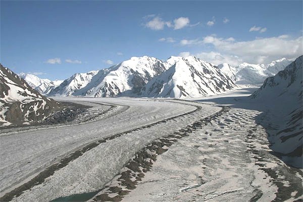
Picture 3.1. Glacier named after Fedchenko where Vakhsh River starts.
Debris, which forms so-called moraines - ledges shifted by the glacier
Stones at rockslides (see Picture 3.2) are moving down by gravity,
they rub and strike each other, and gradually they break into smaller
pieces.
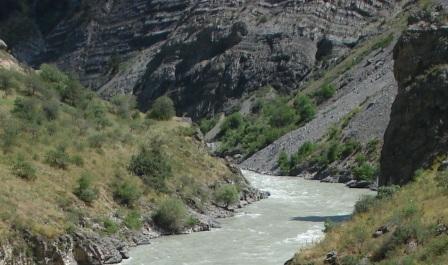
Picture 3.2. Rockslides to the right of mountain river formed from
rock debris are clearly seen at the picture (Chatkal River, it is
tributary of Chirchik River in Uzbekistan).
Force of gravity, rains and snow contribute to their replacement
to bottom of washes, flows and rivers. Unruly streams aroar pass
over them when snowmelts and rainfalls take place in spring season.
Stones are picked up by these flows and deliver them to big rivers.
The stones moved by water continue with breaking down of mutual
collisions and forming smaller pieces of rock.
Intermediate size of stones are gradually reduced in river valleys
from head reach to lower coarse as far as river slopes and its velocities
are reduced, because water velocity depends on slope mainly, and
capability to move deposits in form of stones, sand and clay particles
depends on water velocity
Simultaneously, together with stones breaking down into smaller
pieces during their transferring in river channel, change of their
shape are in process - shapeless stone pieces with sharp edges are
pelletized and turn into rather smooth and get rounded shape
At Picture 3.3 we can see stones of big size which were delivered
by small flows in mountain, and at Picture 2.4 we can watch significantly
smaller sizes of stones in flood plain of the river at site of its
coming out from mountains
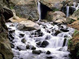
Picture 3.3. Slightly rounded by water stones could be seen along
channel of mountain flow.
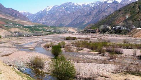
Picture 3.4. Typical view of Angren river valley at its exit to
piedmont. The river is divided into several channels (river branches)
at its flood plain. All the flood plain is filled with water only
during flood period. Water flow capability here is enough to transfer
only small and mainly rounded stones.
As rates of stream flow are changed along seasons of a year, then
capability of rock debris transferring depends very much of that.
Rivers are capable to transfer more coarse waste during flood (period
of sharp increase of water discharges which take place as a result
of glaciers and snow cover melting or rains), but during low water
season (period of low water in river -is in autumn and winter),
rivers are fed mainly only with groundwater - and they are capable
to transfer only smallest, clay particles.
These processes are repeated every year.
The farther rivers are from mountains, the fewer slopes they have
and fewer velocity of water in the rivers we watch. Slope is relationship
of elevations difference between the two sites divided into distance
between the sites, or in other words - changing of height per unit
of length (of river, furrow, road etc.). Transferring capacity of
water is reduced accordingly because capacity to entrain and transfer
particles of different size depends on water velocity. Coarse grains
at first, then smaller particles begin to deposit on bottom. The
smallest particles - particles of clay, are deposited at lakes and
old channels which were separated from main river channel during
high water period.
Several million years' history has our Mother Earth. Lots of mountains
were ruined down to rock bottom and turned into sand, fine and clay;
more young mountains are arisen and ruined beneath our eyes. Rivers
deliver debris from mountains to valleys night and day. Climate
was changed repeatedly at some parts of our Planet during this period.
After periods of high water, dry time came. Rivers appeared and
disappeared. Hurricanes and dust storms sorted and moved huge amount
of river deposits that was moved to plains during high water periods.
Look at the map (Picture 3.5), and you will see two main rivers
of Central Asia - Amudarya and Syrdarya, which were inflowing in
Aral Sea not far ago, they delivered huge amount of debris during
millenniums of their existence and formed two well-known deserts
there - Kara-Kum and Kizil-Kum, and number of steppes closer to
mountains.
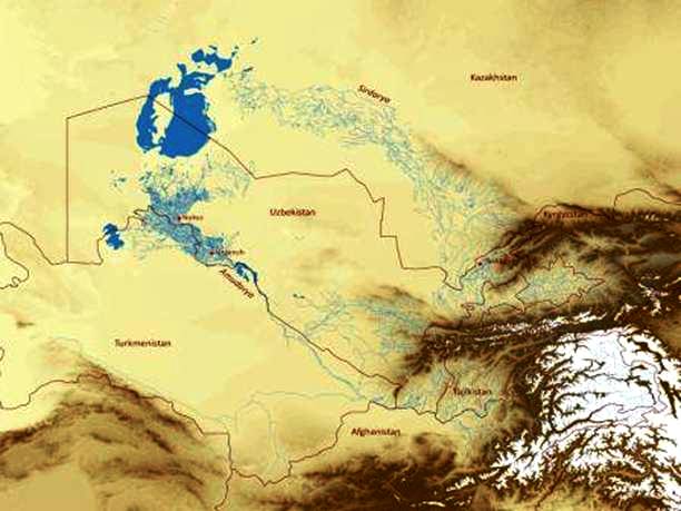
Picture 3.5. Fragment of Central Asian Region.
Aral Sea as of approximately 1993. From mountains down to Aral
Sea enormous areas of steppes and deserts were filled with debris
by the two great rivers. (White color - glaciers, brown - mountains,
grey-yellow -steppes and deserts, rivers and canals - were shown
by blue lines).
Wind plays not insignificant role in movement of soil materials.
Sediments delivered for distance of hundred and thousands kilometers
to steppes and deserts by powerful flows of water during flood periods,
and after the floods decline and drying, the sediments are subject
to strong winds, that can have velocity at open flat areas comparable
with express train. From spring to autumn strong dust storms take
place close to deserts, and then sky is getting of yellow-brown
color due to dust.
Satellite photograph at Picture 3.6 shows cyclone over China, which
carries huge amount of dust having common to loess soils fawn color.
Loess is sort of sediment that consists of silt particles mainly
which were transferred by wind.
Wind is doing a kind of "separating plant" of sediments.
Stones, gravel and coarse sand can not be shifted even by very powerful
wind, and they are left more or less at the same site where they
were transferred by water. Sand can move "on all fours"
and fill massive barchans (dunes) that were shown at Picture 3.7.
But small particles of dust picked up by wind are transferred to
huge distances, and after wind velocity reduction, the particles
start deposit on surface. As a result of that, so called loess massifs
appeared at piedmont areas where wind velocities blowing from deserts
are reduced because mountains are obstacle for them .
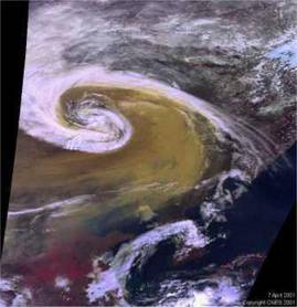
Picture 3.6. View of huge cyclone over territory of China. Tremendous
dust mass of specific color of loess transferred to huge distances
are clearly seen at the satellite image.
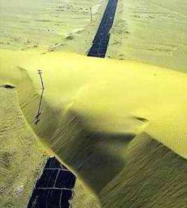
Picture 3.7. Wind storm shifted overlarge barchan (sand dune) which
blocked road.
Loess massifs are also common to other sites, where wind velocities
are reduced for some other reasons and dust particles are deposited
above ground.
Loess deposits in piedmont area of Tashkent oblast were shown at
Picture 2.8
Please, pay attention to uniform structure of soil profile in depth
and the wash slopes are vertical and that is one of attributes of
loess
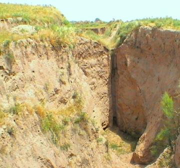
Picture 3.8. Loess deposits near Tashkent that cut by water flows
Thickness of Loess deposits can reach several decades of meters.
Could you imagine how long it took for formation of such thickness
of loess, if dust layer deposited during one year in usual conditions
is not more 1-2 mm per year!
Loess like a jacket covers piedmont area and extends along mountain
massifs. Its properties, irrespective of location are very similar
and practically indistinguishable (in China, Central Asia or in
Europe), possibly because of their sources are rather far from deposited
sites, and material was well-mixed in air while it transfered by
wind for thousands kilometers
One of loess characteristics is its high uniformity in depth, high
porosity (total volume of all the pores expressed in % to soil volume),
fine wicking properties (capability to lift moisture by means of
adhesive power with soil particles), very good water holding properties,
stability in dry condition and capability of quick erosion by water.
So, we remind you, how crushes of rock are delivered to flat lands
by water flows and how they are sorted in accordance with their
fragmentation size. Then these sediments are sorted again, but by
wind power, and they partly are returned back to mountain sideward,
forming loesslike soil substrate in piedmont areas.
But it is not finish for silt formed the loess massifs. The massifs
are "suppliers" of sedimentary materials, which are eroded
and transferred by water flows during snow melting, spring rainfalls,
or as a result of unskillful irrigation at irrigated fields. Even
small water discharges needless to say about flows of high capacity
can easily erode loess (see Picture 2.8) and they transfer it again
from piedmont areas towards steppes and deserts.
Sometimes they form massifs of re-deposited loess massifs when they
are deposited at flat lands (for instance, geologists believe, that
soils at Golodnaya Steppe in Uzbekistan mainly formed with such
rocks).
Re-deposited loess differs from genuine loess by specific stratification
common to all sedimentary strata that formed by water flows, but
many of their initial properties they keep also after that.
Usually, re-deposited sedimentary strata are very stratified, especially
if they were formed on the basis of older sedimentary strata, and
thus availability of high or low water permeability layers can have
impact on moisture regime of root zone.
We described in brief on typical processes of soil substrate forming
by the example of Central Asia. Glaciers and lakes with swamplands
took part in these processes at other places during long Earth history,
but anywhere main operators were water and wind.
But it is worth to say, that soils can be formed with any of rocks,
including crystallinoclastic rocks, sandstones, limestone, lake
and sea deposits.
In the next articles of this website section we shall continue telling
on how and where climatic conditions and topography form different
soils on the basis of variety of substrates.
Contacts with us
Back to home page.