N.Sh.
Sharafutdinova
Method for taking of
the decisions about a choice inspection points number for maintenance
of authentic salt shootings.
Central Asia scientific
research institute of irrigation named after V.D. Zhurin, Uzbekistan
For efficient control
melioration by a condition of dabbled grounds it is necessary to have
the qualitative information. Now information on a salinization of
lands has not sufficient veracity, as 1 point of test on 25-50 ga
is carried out on the basis before an offered technique. On the basis
of such data the cards of a salinization of lands are under construction,
and the distribution of water resources out of vegetation the season
for their leaching is planned.
At such density of saline examination the accuracy of the received
information about a salinization does not meet the requirements control
of water and land resources. More objective data for optimum control
of these resources today can be received by usage of stuffs of remote
filming (space snapshots), terraneous information with application
of a geographic information system (GIS).
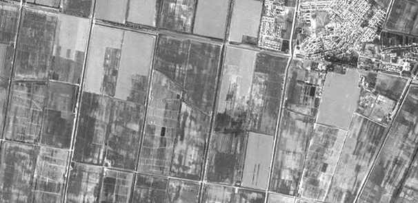
Fig. 1. A view of a part
of Siddikov farm in Syr-Darya area from space.
The snapshot is made from a satellite IRS 1C in August, 2000.
Usage of space snapshots
in realization of terraneous examinations of dabbled terrains gains
now large value in an agricultural production.
Usage of space snapshots allows to receive the reliable information
about accommodation of agricultural cultures and their condition and
to improve of monitoring salinity of soils, which one usually estimates
through projective cover (at this method), and also in conditions
of economies of water resources to conduct measures on capital washdown
of grounds, there, where it is necessary.
However at the given stage space snapshots, equipment both software
for image processing and binding of coordinates, while that have restricted
application basically on the causes of unavailability of the space
information and availability of the equipment for their processing.
It is known, that the obtaining of a qualitative crop, depends on
set of the factors, therefore, applying only space snapshots cannot
be established the true cause of low projective cover, that is not
always it is possible to interprete low projective cover with a salinization
of soils, terraneous monitoring at all levels controls of water and
land resources therefore should be perfected.
Studying a high-res (6 § 6 ņ2) panchromatic snapshot executed in September,
2000 from Indian satellite IRS 1C (the Fig. 1) on a piece of terrain
of Dzhizak and Syr-Darya areas is possible to make one of main conclusions
that by a severe problem in these areas and in other too introduces
poor quality of a design of grounds. On a piece of a space photo the
part of Siddikov farm is adduced. Tag of this severe problem of dabbled
grounds on a space snapshot is the diversity of the maps of fields
under a cotton plant. The quality of a design is directly connected
to a quality and quantity of distribution of sprinkling water on irrigation
a plot and it is in case of 1-th or 2 waterings. The diversity (heterogeneity)
of a surface of the Earth (vegetative cover)could be reduced for the
score of more often waterings compensatory evapotransperation of plants
and vaporization of soil. As a result, it essentially has an effect
for losses of a crop at the expense of irregular maintenance of an
accessible edaphic moisture and diversity of a salification of soil
in limits irrigation the plot.
The space snapshot can be scaled up to M 1:5000, thus all parts will
be rather well saved. On a snapshot of IRS 1C a condition of a collector
system - overgrown and furbished of a header - also is well visible.
For reliable maintenance by the terraneous data of the space information,
for its authentic decoding it is necessary to have in terrain of each
area a system of test (monitoring) fields (plots) with the size of
the party not less than 120-150 m for each main culture. And, their
accommodation should be made on fields with a different degree of
a salification - none saline or slight, medium saline, very saline
and very much saline.
It is known, that the main cultures cultivate in Uzbekistan, are cotton,
grain-crops and rice. On test plots with these main cultures researches
owe to be carried out giving full representation about a course vegetation
of processes. Having supplied good coordinate binding of such plots,
it is supposed to receive authentic decipherment tags for theme processing
of space snapshots.
Allowing, that the estimation of a melioration condition of dabbled
grounds intimately is connected to other problems of monitoring, it
owes to be informational supplement to a general system of monitoring
of the agronatural complex of Republic of Uzbekistan and, simultaneously,
to receive the indispensable information from other subsystems of
monitoring.
In farms, on projective cover, besides of diversity of an edaphic
cover, the level of an agricultural production (agrotechnics etc.)
will influence considerably.
For exact comprehension and the treatments of the space information,
it is necessary to know the terraneous data, which one can be obtained
on representative plots for the given zone, test fields (plots).Such
plots can take the area from 100 up to 300 ga and encompass whenever
possible all degrees of a salification of soils.
Now in SANIIRI, with the help of such test plots indispensable quantity
of points of boring for terraneous examinations is updated. The technique
wastes on a test plot Okkaltin of region of Syr-Darya area by the
area 270 ga, where the spring of 2000 gobed up 277 points of examination
at density of backfill 1 point on 1 ga. On a salinization the plot
corresponded to the above-stated requirements. The salinization in
each point (horizon 0-60 cm) was determined through an electroconductometer
the X-express.
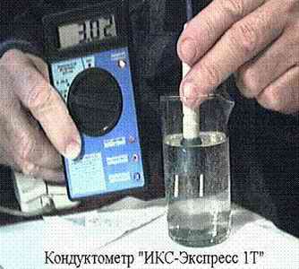
Fig. 2. Measurement salinity
of edaphic solution improved (2000)
By model of a conductometer the X - express 1ę.
The estimation of a salinization
of soils was conducted on classification FAO.
The table 1. FAO classification
salinity of soil
| Degree
salinity of soil |
┼čÕ,
dS/m
|
| None saline |
0-2
|
| Slight
|
2-4
|
| Medium
saline |
4-8
|
| Very
saline |
8-16.
|
| Very much
saline |
>16
|
With the help of a statistical
analysis on the PC, the reduction of number of points from general
sampling (till 20 % from their general number) was made singlestep,
even on the area. Thus on the schedule of a test plots in the beginning
was moved each fifth point, then each fourth and so on. At different
"moving" of points with the help of the program "Surfer",
the cards of a salinization were constructed and the outcomes of distribution
of miscellaneous degrees of a salinization of soils are compared,
as though at miscellaneous density of backfill of points of examination
(Fig. 3).
The cartograms of a salinization of soils are constructed by the program
"Surfer". The coordinates of each tapping point were fixed
at the help GPS, with their subsequent binding on location at creation
a hybrid module. It was necessary to us to straighten out, as the
obtained information mirrors an actual picture salinity of soils.
For want of the program "Surfer" and capabilities of construction
of cards, it is possible will limit only by statistical data processing.
However, the activity with cards gives best and more visual outcomes.
In a fig. 3 is rotined as, the exterior of a card changes at a decrease
of number of points: small contours generate, as a result of which
information changes.
The matching of the sizes of the areas with a different degree of
a salification at 100 % -, 20 % - and 10 % -ĒŅķ to backfill of points
(i.e. at density of backfill 1 point on 1 ga, 1 point on ~ 5 ga and
1 point on ~ 10 ga accordingly) has allowed to establish, that at
a decrease of quantity of points up to 20 and 10 %, the outcomes miss
within the limits of 13 % (tab. 2).
The table 2. Influencing of series "moving" of points of
examination On percent of distribution of soils with different degrees
of a salinization
|
Degree
salinity of soil
by ┼čÕ, dS/m
|
Number
of points, included in sampling, %
|
Percent
of a divergence in relation to initial quantity of points, at
|
|
100
|
60
|
40
|
20
|
10
|
20
%
|
10%
|
| None saline
and slight |
20
|
18
|
12
|
10
|
26
|
-10
|
+6
|
| Medium
saline |
37
|
37
|
32
|
44
|
24
|
+7
|
-13
|
| Very saline
and very much saline |
43
|
45
|
56
|
46
|
50
|
+3
|
+7
|
| The total
saline soils |
80
|
82
|
89
|
90
|
74
|
+10
|
-6
|
The notice: 100 % -1 points
on 1 ga; 60 % - 1 point on 1,6 ga; 40 % - 1 point on 2,4 ga; 20 %
- 1 point on 4,8 ga; 10 % - 1 point on 9,6 ga
From tab. 2. it is visible,
that in conditions of experience at reduction of number of points
with 100 up to 20 % the divergence in the data about none saline and
d slight grounds makes approximately 10 %. The reduction of quantity
of points results in increase of the area medium saline of grounds.
In outcome is established, that at monitoring a salification of soils
in conditions of Syr-Darya area indispensable and sufficient density
of backfill is: 1 point of examination on 5 -6 ga.
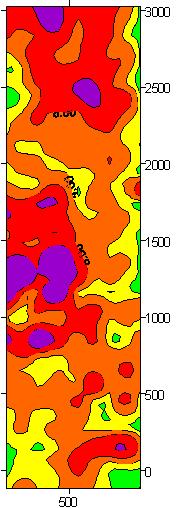 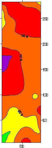 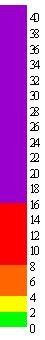 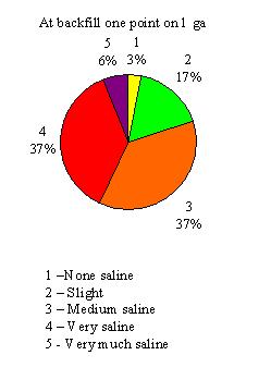 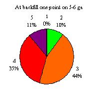
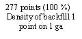 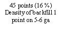
Fig. 3. Influencing of
density change of tapping points of assays on a view of a card of
a salinity
The designed data processing
methods obtained on test plots, allow to determine statistically reasonable
density of backfill of points of examination practically for any conditions
(Fig. 4).
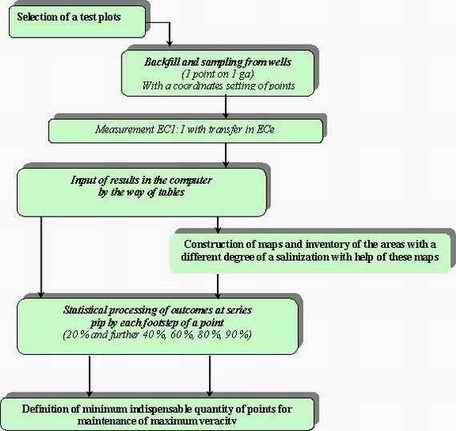
Fig. 4. Stages of activities
for the reasonable quantity of points of saline examination of a representative
plot
The technique of the reasonable selection of density of backfill of
points for examination of the salted grounds can be advised for Hydrogeological
and melioration of expeditions the Ministry of Agriculture and water
management of Republic of Uzbekistan.
The conclusion
For definition of indispensable
quantity of points with reference to other conditions it is recommended:
1. To select a test plot, area not less than 100 ga representative
on salinity of soils for the given terrain;
2. To conduct initial saline filming at density of backfill of wells
1 point of examination on 1 ga (horizon 0-30 and 30-60 cm) with definition
salinity by a way of an electroconductometry soil - water suspension
with the subsequent recalculation ┼č1:1 in ┼čÕ and calculus of average
values ┼čÕ in a layer 0-60 cm;
3. To construct and to compare on the computer to usage of the program
"Surfer" test cards at series let 20, 40, 60, 80 % of points
(uniformly on the area of a points to compare them, to reveal distribution
of the areas with a different degree of a salification of soils.
It is possible to consider sufficient that least quantity of points,
at which one the convergence with distribution of the areas on the
degree salinity lays within the limits +10 % (in relation to distribution
at 100 % of points).
Method for taking of the decisions about a choice inspection points
number for maintenance of authentic salt shootings.
Summary
To improve the reliability
of monitoring results of salinization of soil, the method, defining
the density of a choice of inspection points has been developed.
The method was worked through on a test plot in Okkaltin region of
Syr-Darya oblast (area 270 ga), where in spring 2000 277 inspection
points were incorporated of at density of a choice 1 point on 1 ga.
At the statistical analysis the reduction of points number from the
general sample till 20 % from their general number was carry out step-by-step,
uniform by on the area, at the same time on the plan of a test plot
each fifth point, then every fourth and so on was removed
The data processing through the computer programs Excel and Surfer,
has allowed to calculate the necessary and statistically proved number
of points of approbation on the given test site for improvement of
the control salinity.
It is established, that for the control of seasonal salinization of
soil under conditions of Syr-Darya area the density of a choice is
necessary and sufficient: 1 point of inspection on 5 -6 ga.
The developed method, substantiation of density of the choice of inspection
points with the help of representative, test sites can be recommended
for OGME.
Return
to the main page
How
to contact us
|