Morozov
A.N.
Lecture 1. Natural environment
of Uzbekistan
As for natural environment, Uzbekistan territory
is unique. Wealth of alpine meadows and big glaciers high up in the mountains,
archa bushes and gardens at medium belt of mountains, beautiful spring-fall ranges
at low mountains piedmont chules (steppe), extremely rich irrigated lands at valleys
of rivers, major says (flows) and undulated plains at piedmonts, horizonless steppes
gradually join with deserts.
Most important attributes that determine
human comfort and indeed practically most aspects of his activity are land topography
and its climatic features. Land topography determines groundwater formation conditions,
their mineralization and irrigation capability, and climate - defines many aspects
of business activities, natural grows species and types and necessity of irrigation
for crops cultivation.
Several maps can be found below where successively
shown followings:
Uzbekistan administrative division, its view from aerospace
with showing administrative division and without one.
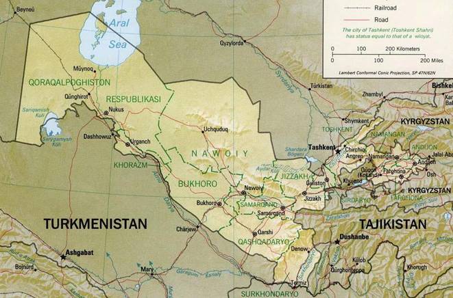
Picture
1.1. Administrative division of Uzbekistan and of neighboring countries..
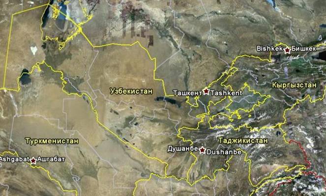
Picture
1.2. Aerospace view of Amu Darya and Syr Darya interfluve with showing borders
of countries and oblasts.
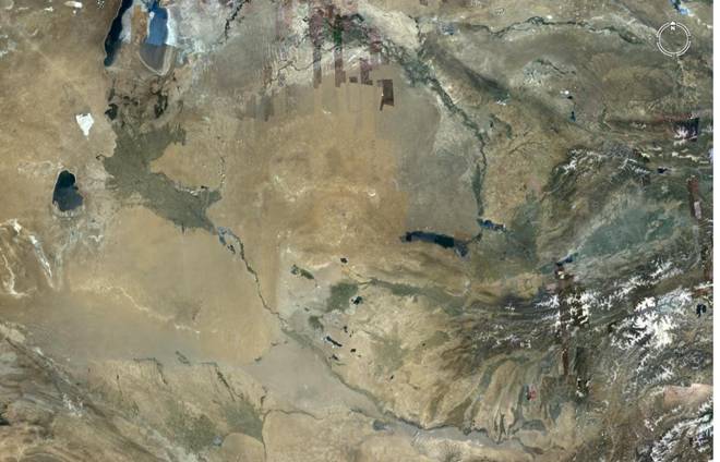
Picture
1.3. Aerospace picture of Amu Darya and Syr Darya interfluves.
Natural
features of Uzbekistan territory are seen rather good enough at Picture 1.3. Please,
look at it carefully. The picture gives a glimpse of Uzbekistan territory topography
and of adjacent areas of neighboring countries. White glaciers are clearly seen
in the mountains. The mountains highlighted with dark color, irrigated areas colored
with moss-green. Steppes and deserts have oatmeal- brown tincture.
About
how strata formations under soil, groundwater flows formation, seepage flows and
their salinity are dependent on surface topography we shall tell in our next lectures
related to origin of soils salinity and taking over control this effect. Here,
we shall tell only that groundwater depth and their mineralization have significant
influence to forming of soil types and their fertility, and they mainly determine
necessary regime of irrigations with their rate either.
For more detailed
view on climate of various territories of Uzbekistan, as a graphical example and
for comparison, monthly mean air temperatures, its relative humidity (drought)
and precipitation amount are shown at Pictures 1.4 - 1.6
These data
were given for several indicative observation points, including Sherabad town
in Surkhandarya oblast, (the most hot observation point at the very south of Uzbekistan),
Nukus town in Karakalpaia (that is one of the very North stations) and a meteorological
station located at foothill of central zone of Uzbekistan - at Dzhizak town.
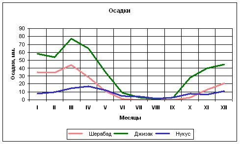
Picture
1.4. Comparison of meteorological precipitation amount (mm) between the three
meteorological stations of Uzbekistan.
As it could see at Picture 1.4 most
of all precipitation occurs during winter-spring and autumn periods. Precipitation
are six times more at foothill area (e.g. Dzhizak meteorological station) than
at north of the republic at Nukus town, and twice more than at south of the republic
at Sherabad meteorological station.
It will be observed, that precipitation
amount during summer months at all the stations is inappreciable, but water requirement
is - maximal.
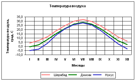
Picture
1.5. Comparison of monthly mean air temperatures between the three meteorological
stations of Uzbekistan.
It can be seen at Picture 1.5 that monthly mean
air temperatures are much higher at south of the republic, and substantially they
are above freezing all year long. Winter period lowest temperatures are observed
at north of the republic.
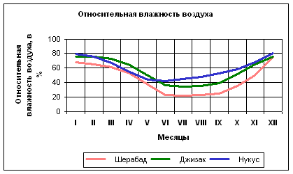
Picture
1.6. Comparison of monthly mean air relative humidity (drought) between the three
meteorological stations of Uzbekistan.
The more air drought is, then the
less moisture is in it (as a percentage of maximal possible moisture contents
in the air in the form of steam at this temperature). As it can be seen at Picture
1.6 air drought is growing naturally from north to south. Air drought is the lowest
at foothills during winter-spring period.
Let us have a look at Picture
1.7, we can see general view there - where and how much precipitation takes place
at Uzbekistan territory during a year. It is clearly seen at the picture that
most of all precipitation take place in mountainous areas, less - at foothills
and quite small amount - at flat land
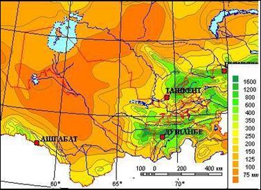
Picture
1.7. Distribution of atmospheric precipitation (annual) over Uzbekistan territory.
Most
important climate indicators are, so called:
"evaporative capacity
from water surface" and
"humidity deficit".
First indicator
was obtained empirically by comparison of actual evaporation against above mentioned
one (of temperature, relative humidity) and corresponded to water sheet which
is evaporated from water surface during a month, and second indicator is difference
between evaporation capacity from water surface and amount of atmospheric precipitation.
At
Picture 1.8 we show values of "evaporative capacity from water surface",
and at Picture 1.9 - "humidity deficit" for the same indicative meteorological
stations.
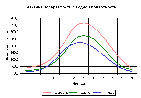
Picture
1.8. Values of "evaporative capacity from water surface" and of "humidity
deficit" for the same indicative meteorological stations.
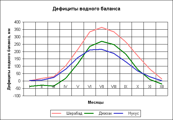
Picture
1.9. Values of "water balance deficits" for the indicative meteorological
stations.
As judged by climatic indicators, more than half of Uzbekistan
territory is in arid climate zone. What it does mean can be read in the encyclopedia:
"Arid
climate (A.C.), climate of deserts and semideserts. It is typical for A.C.: high
day and annual air temperatures; almost a total absence or trace amount of precipitation
(100 - 150 mm/year). All coming water is evaporated rapidly. Rivers, flowing from
neighboring more damp fields and crossing desert, here are getting shallow and
often end at drainless depressions with salt lakes. Naked earth surface meet with
temperature dancing within 24 hours, and because of that even compact rocks are
ruined and turn into sand. Wind shift huge amount of dry sand and forming rolling
topography of sand barchans and shifting sands. A.C. is most typical for tropical
and subtropical latitudes (Sahara, deserts of Arab Peninsula, of Australia). A.C.
at more high latitude is connected with protective effect of mountain ranges which
prevent from moisture transfer from oceans (deserts of North and South America),
or with farness from oceans (deserts of Central Asia)
You will find an
answer in the next articles of the website - what for we discussed the issue on
climate features and showed Uzbekistan maps with topography of its territory.
Contacts with us
Back
to home page.